
Photo by Kristine Wook
MANILA, Philippines — For communities surrounding Manila Bay, flooding is no longer only about how much rain falls. The land itself is gradually sinking, allowing floodwaters, high tides and storm surges to reach farther inland and remain longer.
The issue returned to national attention after businessman Ramon Ang said that ground subsidence and rising sea levels—not the construction of the New Manila International Airport—are driving widespread flooding in Bulacan.
Scientific studies support the broader connection between sinking land and worsening floods. However, subsidence does not create heavy rainfall. Instead, it lowers the elevation of the ground, making existing flooding deeper, more extensive and more difficult to drain.
Why the Ground Is Sinking
Land subsidence is the gradual downward movement of the ground.
Researchers from the University of the Philippines identified several contributing factors: excessive groundwater extraction, rapid urbanization, tectonic movement and the natural compaction of young sediments beneath cities.
Groundwater extraction is considered a major human-induced driver. When large amounts of water are pumped from underground aquifers, clay and other sediments can compress. Once compacted, the ground above them sinks.
Industrial, commercial and residential areas often require substantial amounts of water. Researchers found that many of the fastest-sinking locations coincide with industrial complexes and densely populated communities.
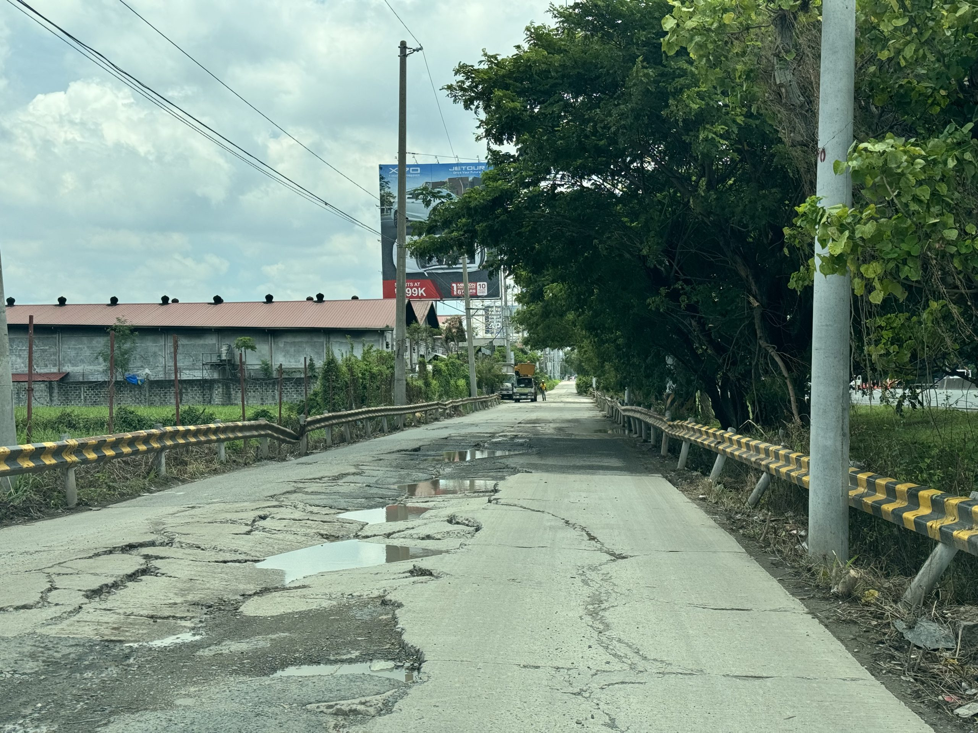
Image from UP Geologist Report
Areas With the Highest Reported Subsidence Rates
The figures below come from different studies, observation periods and measurement methods. Some areas overlap, so the table should not be interpreted as a single province-wide ranking.
| Affected area | Reported subsidence rate | Easy conversion | Measurement context |
| Hagonoy and Calumpit groundwater-extraction hotspots | Up to 124.5 mm/year | 12.45 cm/year | Recorded in selected areas near intensive extraction points from 2015 to the first quarter of 2021 |
| Guiguinto, Bulakan and Balagtas | Maximum of 109 mm/year | 10.9 cm/year | Maximum rate from the 2014–2020 satellite analysis |
| Already-developed Manila Bay coastal areas | Up to 90 mm/year | 9 cm/year | Localized rates reported for developed coastal zones |
| Proposed reclamation zones | Up to 60 mm/year | 6 cm/year | Reported maximum in selected proposed reclamation areas |
| Northern-bay coastal sectors, including Malabon, Navotas and parts of Bulacan | 20–40 mm/year | 2–4 cm/year | Coastal-sector estimates showing a strong north–south difference |
| Port of Manila monitoring site | About 10.1 mm/year | 1.01 cm/year | Site-specific rate calibrated from tide-gauge and satellite records; not a citywide average |
| Las Piñas | Roughly 6 mm/year | 0.6 cm/year | Approximate rate in the 2014–2020 study |
A separate analysis of Hagonoy and Calumpit reported an average subsidence rate of 70.2 millimeters per year within 500 meters of pumping stations, reinforcing the observed relationship between intensive groundwater extraction and faster sinking.
The 2014–2020 University of the Philippines study identified the combined Guiguinto-Bulakan-Balagtas zone as Bulacan’s fastest-sinking area, with a maximum rate of 109 millimeters—or nearly 11 centimeters—per year.
How Subsidence Makes Flooding Worse
When the ground sinks, communities lose elevation relative to rivers and the sea. Depressed areas can form basin-like zones where water naturally collects.
In coastal communities, the danger is compounded by rising sea levels. The land moves downward while the water level moves upward, increasing what scientists call relative sea-level rise.
The result can be:
- Flooding during ordinary high tides
- Deeper inundation during heavy rain
- Slower drainage of floodwaters
- Greater exposure to storm surges
- Permanent seawater intrusion into homes and roads
In Tawiran Village in Obando, seaside roads have been inundated during high tide, while some ground floors have become permanently submerged. In Pariahan Village in Barangay Taliptip, Bulakan, an area that was once walkable has reportedly remained flooded since the early 2000s.
The same transformation is visible on Binuangan and Salambao islands. High-tide flooding has become part of daily life, and many older homes on Binuangan are already uninhabitable or permanently exposed to seawater.
Satellite monitoring cited by the Pulitzer Center found that parts of Bulacan and neighboring Pampanga had sunk by approximately 4 to 6 centimeters since 2003. The destruction of much of Manila Bay’s mangrove cover has also weakened a natural barrier that once helped hold coastal soil in place and absorb the force of waves and storms.
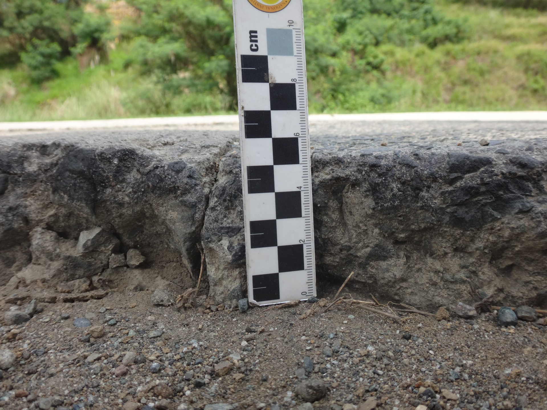
Image from UP Geologist Report
Manila Faces the Same Long-Term Threat
A 2026 study concluded that human-induced ground subsidence is likely the dominant contributor to relative sea-level rise in Metro Manila, accounting for an estimated 55% to 75% of the projected change under the scenarios examined.
Under the study’s high-emissions scenario, approximately 7.95 square kilometers of Metro Manila could face permanent, ocean-connected inundation by 2100, increasing to 11.15 square kilometers by 2150. Malabon, Navotas and Manila’s coastal districts were identified as the areas with the greatest concentration of exposure.
These are projections rather than certain outcomes. They depend on assumptions about future greenhouse-gas emissions, groundwater management and whether the current rate of subsidence continues.
The Sinking Can Be Slowed
There is evidence that intervention can make a difference.
The 2014–2020 study found that subsidence in the CAMANAVA area—Caloocan, Malabon, Navotas and Valenzuela—had declined from previously reported rates of 35 to 40 millimeters per year to roughly 15 millimeters per year. Las Piñas declined from around 17 millimeters to approximately 6 millimeters per year.
Researchers linked the improvement to groundwater restrictions introduced after authorities recognized the problem. They recommend sustainable groundwater use, better water-management practices and long-term satellite and ground monitoring.
The evidence points to a simple but urgent reality: flood-control structures alone cannot address every dimension of the crisis. If groundwater extraction and land subsidence continue unchecked, roads, drainage systems, seawalls and buildings will be forced to operate on ground that is steadily losing elevation.
For Manila and Bulacan, the fight against flooding is therefore taking place on two moving fronts—the water is rising, and the land beneath it is sinking.
Salin sa Tagalog
Lumulubog ang Lupa sa Paligid ng Manila Bay — at Lalong Mahirap Takasan ang Baha sa Bulacan
Sinabi ng mga siyentipiko na ang labis na pagkuha ng tubig sa ilalim ng lupa, pagsiksik ng lupa at pagtaas ng dagat ay lumilikha ng mapanganib na kombinasyon sa ilan sa mga lugar na pinakamadalas bahain sa Pilipinas.
MANILA, Pilipinas — Para sa mga komunidad sa paligid ng Manila Bay, hindi na lamang dami ng ulan ang dahilan kung bakit lumalala ang pagbaha. Unti-unti ring lumulubog ang lupa, kaya mas malayo ang naaabot ng baha, high tide at storm surge—at mas matagal bago humupa ang tubig.
Muling napag-usapan ang isyu matapos sabihin ng negosyanteng si Ramon Ang na ang paglubog ng lupa at pagtaas ng dagat—at hindi ang pagtatayo ng New Manila International Airport—ang nagtutulak sa malawakang pagbaha sa Bulacan.
Sinusuportahan ng mga pag-aaral ang mas malawak na koneksiyon ng lumulubog na lupa at lumalalang pagbaha. Gayunman, hindi lumilikha ng malakas na ulan ang subsidence. Pinabababa nito ang lebel ng lupa, kaya nagiging mas malalim, mas malawak at mas mahirap patuyuin ang umiiral nang baha.
Bakit Lumulubog ang Lupa?
Ang land subsidence ay ang unti-unting pagbaba o paglubog ng ibabaw ng lupa.
Tinukoy ng mga mananaliksik mula sa University of the Philippines ang ilang posibleng dahilan: labis na pagkuha ng groundwater, mabilis na urbanisasyon, paggalaw ng lupa dahil sa tectonic activity at natural na pagsiksik ng mga batang sediment sa ilalim ng mga lungsod.
Itinuturing na pangunahing dahilan na gawa ng tao ang labis na groundwater extraction. Kapag napakaraming tubig ang ibinobomba mula sa mga aquifer, maaaring magsiksikan ang clay at iba pang sediment. Kapag nagsiksikan ang mga ito, bumababa ang lupang nasa ibabaw.
Malaki rin ang pangangailangan sa tubig ng mga industrial, commercial at residential area. Natuklasan ng mga mananaliksik na marami sa pinakamabilis lumubog na lugar ay matatagpuan malapit sa mga industrial complex at matataong komunidad.
Mga Lugar na May Pinakamataas na Naiulat na Subsidence
Galing ang mga numero sa magkakaibang pag-aaral, panahon ng obserbasyon at paraan ng pagsukat. Nag-o-overlap ang ilang lugar, kaya hindi dapat ituring ang talahanayan bilang iisang ranggo para sa buong lalawigan.
| Apektadong lugar | Naiulat na bilis ng paglubog | Mas madaling sukat | Konteksto ng pagsukat |
| Mga hotspot sa Hagonoy at Calumpit na malapit sa groundwater extraction | Hanggang 124.5 mm/taon | 12.45 cm/taon | Naitala sa mga piling lugar malapit sa intensive extraction points mula 2015 hanggang unang quarter ng 2021 |
| Guiguinto, Bulakan at Balagtas | Pinakamataas na 109 mm/taon | 10.9 cm/taon | Maximum rate mula sa 2014–2020 satellite analysis |
| Mga developed coastal area sa Manila Bay | Hanggang 90 mm/taon | 9 cm/taon | Localized rates sa mga nabuo nang coastal zone |
| Mga proposed reclamation zone | Hanggang 60 mm/taon | 6 cm/taon | Naiulat na pinakamataas na rate sa ilang planong reclamation area |
| Northern-bay coastal sectors, kabilang ang Malabon, Navotas at ilang bahagi ng Bulacan | 20–40 mm/taon | 2–4 cm/taon | Mga pagtataya sa coastal sectors na nagpapakita ng malaking pagkakaiba sa bawat lokasyon |
| Monitoring site sa Port of Manila | Humigit-kumulang 10.1 mm/taon | 1.01 cm/taon | Site-specific rate mula sa tide-gauge at satellite records; hindi average ng buong Maynila |
| Las Piñas | Humigit-kumulang 6 mm/taon | 0.6 cm/taon | Tinatayang rate sa 2014–2020 study |
Sa hiwalay na pagsusuri sa Hagonoy at Calumpit, naitala ang average na paglubog na 70.2 millimeters bawat taon sa loob ng 500 metro mula sa mga pumping station. Pinatitibay nito ang nakitang kaugnayan ng matinding groundwater extraction at mas mabilis na subsidence.
Sa 2014–2020 study ng University of the Philippines, ang pinagsamang bahagi ng Guiguinto, Bulakan at Balagtas ang tinukoy na pinakamabilis lumubog sa Bulacan. Umabot sa 109 millimeters—o halos 11 centimeters—bawat taon ang maximum rate nito.
Paano Pinalalala ng Subsidence ang Pagbaha
Kapag lumulubog ang lupa, nawawalan ng elevation ang mga komunidad kumpara sa mga ilog at dagat. Maaaring mabuo ang mga lugar na parang palanggana kung saan naiipon ang tubig.
Sa mga coastal community, lalo pang lumalala ang panganib dahil sa pagtaas ng sea level. Bumababa ang lupa habang tumataas ang tubig—isang kombinasyong tinatawag na relative sea-level rise.
Maaari itong magresulta sa:
- Pagbaha kahit ordinaryong high tide
- Mas malalim na baha kapag malakas ang ulan
- Mas mabagal na pag-agos at paghupa ng tubig
- Mas malaking exposure sa storm surge
- Permanenteng pagpasok ng tubig-dagat sa mga bahay at kalsada
Sa Tawiran Village sa Obando, lumulubog sa tubig ang mga kalsada malapit sa dagat tuwing high tide, habang permanente nang nakababad sa seawater ang ilang ground floor. Sa Pariahan Village sa Barangay Taliptip, Bulakan, ang dating nalalakaran na lugar ay iniulat na permanenteng binabaha mula pa noong unang bahagi ng 2000s.
Makikita rin ang pagbabagong ito sa Binuangan at Salambao islands. Bahagi na ng pang-araw-araw na buhay ang high-tide flooding, at marami sa matatandang bahay sa Binuangan ang hindi na matirhan o permanente nang naaabot ng tubig-dagat.
Ayon sa satellite monitoring na binanggit ng Pulitzer Center, may mga bahagi ng Bulacan at kalapit na Pampanga na lumubog nang humigit-kumulang 4 hanggang 6 centimeters mula noong 2003. Ang pagkawala ng malaking bahagi ng mangrove forest sa Manila Bay ay nagpahina rin sa natural na harang na dating humahawak sa coastal soil at sumasalo sa lakas ng alon at bagyo.
Nahaharap din ang Maynila sa Pangmatagalang Panganib
Ayon sa isang pag-aaral noong 2026, posibleng ang subsidence na dulot ng aktibidad ng tao ang pangunahing dahilan ng relative sea-level rise sa Metro Manila. Tinatayang bumubuo ito ng 55% hanggang 75% ng projected change sa mga sinuring scenario.
Sa high-emissions scenario ng pag-aaral, humigit-kumulang 7.95 square kilometers ng Metro Manila ang maaaring permanenteng abutin ng tubig-dagat pagsapit ng 2100. Maaari itong tumaas sa 11.15 square kilometers pagsapit ng 2150. Malabon, Navotas at mga coastal district ng Manila ang natukoy na may pinakamalaking konsentrasyon ng exposure.
Mga projection ang mga numerong ito at hindi tiyak na prediksiyon. Nakasalalay ang mga ito sa magiging greenhouse-gas emissions, groundwater management at kung magpapatuloy ang kasalukuyang bilis ng subsidence.
Maaaring Pabagalin ang Paglubog
May ebidensiyang nagpapakitang maaaring makatulong ang intervention.
Natuklasan sa 2014–2020 study na bumaba ang subsidence rate sa CAMANAVA—Caloocan, Malabon, Navotas at Valenzuela—mula sa dating 35 hanggang 40 millimeters bawat taon tungo sa humigit-kumulang 15 millimeters bawat taon. Sa Las Piñas, bumaba ito mula sa humigit-kumulang 17 millimeters tungo sa 6 millimeters bawat taon.
Iniugnay ng mga mananaliksik ang improvement sa mga restriksiyon sa paggamit ng groundwater na ipinakilala matapos kilalanin ng mga awtoridad ang problema. Inirerekomenda nila ang sustainable groundwater use, mas mahusay na water management at pangmatagalang satellite at ground monitoring.
Malinaw ang ipinakikita ng ebidensiya: hindi kayang tugunan ng mga flood-control structure lamang ang bawat bahagi ng krisis. Kung magpapatuloy nang walang sapat na kontrol ang groundwater extraction at land subsidence, mapipilitang gumana ang mga kalsada, drainage system, seawall at gusali sa lupang patuloy na bumababa.
Para sa Manila at Bulacan, nagaganap ang laban kontra-baha sa dalawang gumagalaw na direksiyon—tumataas ang tubig habang lumulubog ang lupang nasa ilalim nito.